Home » Digital Transformation » 3D City Twins & Geospatial Mapping

3D City Twins & Geospatial Mapping

Shashikant Kalsha

February 11, 2026

Blog features image

Introduction: Why 3D City Twins and Geospatial Mapping Are Becoming Essential

3D City Twins and geospatial mapping matter because they let you see, simulate, and improve cities before expensive decisions become permanent mistakes.

If you are a CTO, CIO, Product Manager, Startup Founder, or Digital Leader, you already know that cities are not simple systems. They are living networks of people, roads, utilities, buildings, public services, and unpredictable events. One wrong infrastructure decision can cost millions, create public backlash, or lock a city into inefficiency for decades.

This is why the world is moving toward 3D City Twins supported by geospatial mapping. Together, they create a real-time, simulation-ready model of the city.

In this article, you will learn:

  • What 3D City Twins and geospatial mapping really are
  • How they work together in smart city programs
  • Real-world examples and case studies
  • Key use cases (mobility, planning, utilities, resilience)
  • Best practices for implementation
  • Future trends shaping the next decade of city intelligence

What Is a 3D City Twin?

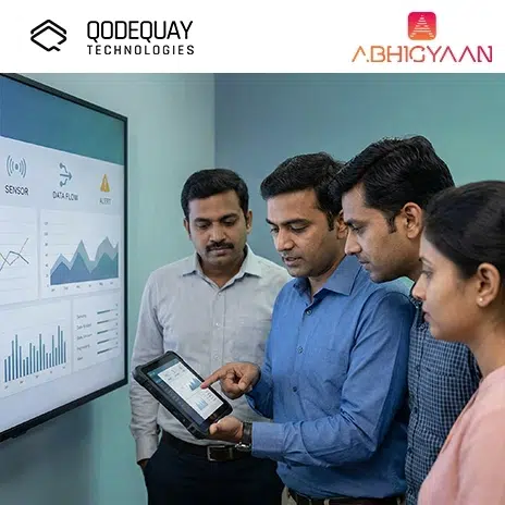
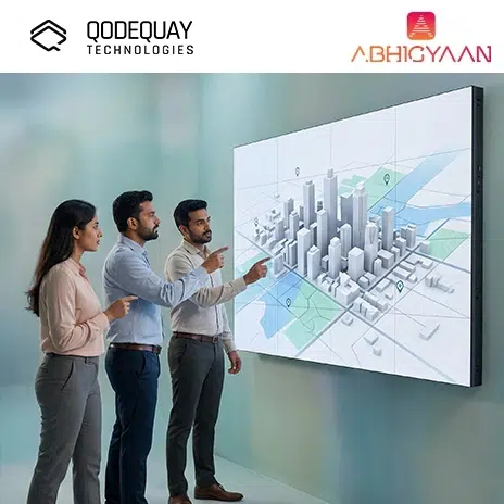
A 3D City Twin is a digital, spatially accurate model of a city that can simulate and monitor real-world conditions.

A 3D City Twin goes beyond a 3D visualization. It becomes a digital environment where you can:

  • View buildings, roads, terrain, and infrastructure
  • Overlay real-time data (traffic, air quality, utilities, weather)
  • Run simulations (flood risk, transport flow, energy demand)
  • Support city operations and long-term planning

Why It’s Called a “Twin”

It is called a twin because it mirrors the real city and updates as the city changes.

The best city twins behave like:

  • A live map
  • A planning tool
  • A monitoring dashboard
  • A simulation engine

All at once.

What Is Geospatial Mapping in This Context?

Geospatial mapping is the process of collecting, structuring, and analyzing location-based data so it can be used for decision-making.

Geospatial mapping is powered by:

  • GIS (Geographic Information Systems)
  • Satellite imagery
  • Drone photogrammetry
  • LiDAR scans
  • GPS data
  • Utility network maps
  • Urban sensor networks

Why Geospatial Data Is the Foundation

A 3D City Twin is only as good as its spatial accuracy.

Geospatial mapping ensures:

  • Every building is in the correct position
  • Terrain and elevation are accurate
  • Roads and assets align correctly
  • Data overlays match real-world locations

Without geospatial accuracy, your “twin” becomes a digital illusion.

How Do 3D City Twins and Geospatial Mapping Work Together?

Geospatial mapping provides the data layer, while the 3D city twin provides the visualization and simulation layer.

Here’s the relationship:

  • GIS data defines the city in coordinates
  • LiDAR and imagery add depth and detail
  • BIM adds building-level engineering accuracy
  • IoT adds real-time behavior
  • The city twin becomes the unified environment

A Practical Example

You want to redesign an intersection to reduce traffic congestion.

With a 3D city twin, you can:

  • Visualize the intersection in 3D
  • Simulate traffic flow during peak hours
  • Test multiple redesign options
  • Predict how changes affect nearby roads
  • Communicate the plan clearly to stakeholders

Instead of guessing, you simulate.

Why CTOs, CIOs, and Digital Leaders Should Care

You should care because 3D city twins turn city data into actionable intelligence and reduce risk in major investments.

Cities are increasingly pressured to deliver:

  • Better mobility
  • Lower emissions
  • Faster infrastructure delivery
  • Higher resilience to disasters
  • Transparent governance

At the same time, budgets are limited and public trust is fragile.

A 3D city twin improves decision quality, reduces waste, and increases transparency.

What Are the Most Valuable Use Cases for 3D City Twins?

The most valuable use cases are urban planning, mobility simulation, utility management, and disaster resilience.

1) Urban Planning and Zoning

You can test:

  • Building height restrictions
  • Sunlight impact on neighborhoods
  • Wind corridors
  • View corridors for heritage sites

This avoids long planning cycles based on static drawings.

2) Transportation and Mobility

You can simulate:

  • Traffic congestion patterns
  • Bus route optimization
  • Pedestrian movement
  • Bicycle lane planning
  • EV charging demand

3) Utilities and Infrastructure Management

You can map:

  • Water pipelines
  • Sewage networks
  • Electrical grids
  • Telecom fiber routes

You can also predict maintenance needs.

4) Disaster and Climate Resilience

You can simulate:

  • Flood risk using terrain elevation
  • Stormwater runoff
  • Heat island effects
  • Evacuation planning
  • Emergency response routing

This is one of the strongest ROI areas because it saves lives and reduces damage.

What Real-World Examples Prove This Works?

Real-world examples show 3D city twins improving planning speed, public communication, and resilience planning.

Singapore (Virtual Singapore)

Singapore has been widely recognized for building one of the most advanced national-level city twin platforms. It supports planning, sustainability, and operational decision-making.

Helsinki (3D City Model)

Helsinki has developed open 3D city models used for planning, energy efficiency analysis, and city development projects.

London (Digital Twin Initiatives)

London has explored digital twin concepts for infrastructure planning and long-term city resilience.

What These Examples Have in Common

  • Strong data governance
  • Multi-department collaboration
  • A clear roadmap for scaling
  • Real use cases tied to real city outcomes

What Data Sources Power 3D City Twins?

3D city twins rely on multiple data sources, including GIS, LiDAR, BIM, satellite imagery, and IoT sensors.

Core Data Layers

  • Terrain and elevation (DEM models)
  • Building footprints and heights
  • Road networks
  • Land use and zoning layers
  • Utility networks

High-Detail Layers

  • LiDAR point clouds for 3D accuracy
  • Drone imagery for building detail
  • BIM models for infrastructure projects

Real-Time Layers

  • Traffic sensors
  • Air quality sensors
  • Weather data
  • Public transport movement data
  • Smart lighting systems

How Do You Build a 3D City Twin Step-by-Step?

You build a 3D city twin by starting with GIS foundations, adding 3D geometry, and then integrating operational data.

A practical roadmap looks like this:

Phase 1: Establish the GIS Base

You need:

  • Accurate coordinate systems
  • Asset mapping standards
  • Clean city data layers

Phase 2: Create the 3D Model

You generate:

  • Buildings
  • Roads
  • Terrain
  • Key infrastructure assets

Phase 3: Add Simulation Capabilities

You enable:

  • Traffic simulation
  • Flood modeling
  • Energy modeling
  • Infrastructure stress testing

Phase 4: Integrate Real-Time Data

You connect IoT and operational systems.

Phase 5: Deploy for Real Use

You deliver:

  • Dashboards
  • Planning tools
  • Public communication views
  • Operational monitoring interfaces

What Are the Biggest Challenges You Must Prepare For?

The biggest challenges are data accuracy, integration complexity, governance, and long-term maintenance.

Challenge 1: Data Fragmentation

City data often lives in silos:

  • Planning department
  • Transport department
  • Utility providers
  • Private contractors

Challenge 2: Updating the Twin

A city changes constantly. If you do not update the twin, it becomes outdated quickly.

Challenge 3: Security and Privacy

City data can include:

  • Sensitive infrastructure locations
  • Citizen movement patterns
  • CCTV integrations

Security is not optional.

Challenge 4: Cost and Scaling

High-quality LiDAR and modeling can be expensive.

That is why phased rollouts are best.

What Best Practices Should You Follow?

You should build city twins as long-term platforms, not one-time visualization projects.

Best Practices (Bullet List)

  • Start with 2–3 high-impact use cases (traffic, flooding, utilities)
  • Build a single city data standard and governance model
  • Use open formats where possible to avoid vendor lock-in
  • Integrate BIM for new infrastructure projects
  • Ensure the twin can be updated continuously
  • Prioritize usability for planners and operations teams
  • Build privacy safeguards for citizen-related data
  • Design the interface for non-technical stakeholders
  • Measure outcomes using planning speed and cost reduction KPIs

How Do You Measure ROI for City Twins?

You measure ROI by tracking planning efficiency, operational savings, and risk reduction.

High-Value ROI Metrics

  • Reduced planning cycle time
  • Reduced infrastructure rework
  • Faster emergency response planning
  • Reduced flood or climate damage impact
  • Lower operational maintenance costs
  • Better citizen engagement outcomes

A 3D city twin pays for itself when it prevents even one major infrastructure mistake.

How Do 3D City Twins Improve Citizen Engagement?

They improve citizen engagement by making complex planning understandable and transparent.

Instead of showing citizens a flat map or technical blueprint, you show:

  • A 3D view of the proposed building
  • Shadow and sunlight impact
  • Traffic changes
  • Noise impact

This increases trust and reduces opposition driven by confusion.

What Is the Future of 3D City Twins and Geospatial Mapping (2026–2030)?

The future will include real-time city twins, AI-driven planning, and immersive interfaces like AR and VR.

Trend 1: AI-Powered City Simulation

AI will help cities:

  • Predict traffic patterns
  • Forecast energy demand
  • Model climate risks faster
  • Optimize zoning strategies

Trend 2: AR and VR City Planning

City planners will walk through proposed developments in AR or VR before construction begins.

Trend 3: Digital Twins for Sustainability

City twins will become central tools for:

  • Carbon tracking
  • Heat island reduction
  • Renewable energy planning
  • Net-zero reporting

Trend 4: Open City Data Ecosystems

More cities will create open platforms where startups and developers can build services on top of city twin data.

Key Takeaways

  • 3D City Twins and geospatial mapping help you design, simulate, and operate cities smarter
  • GIS and spatial accuracy are the foundation of any reliable city twin
  • The highest ROI use cases include planning, mobility, utilities, and resilience
  • City twins improve transparency and citizen engagement
  • Implementation requires strong governance, security, and continuous updates
  • The future is real-time, AI-powered, and immersive

Conclusion

3D City Twins and geospatial mapping represent one of the most important shifts in how cities plan and operate. Instead of working with static documents, fragmented GIS layers, and slow decision cycles, you move toward a living city model that can be monitored, tested, and improved continuously.

For CTOs, CIOs, Product Managers, Startup Founders, and Digital Leaders, this is not only a technology opportunity, it is a leadership opportunity. You can reduce infrastructure risk, accelerate smart city initiatives, and build trust through transparency.

At Qodequay (https://www.qodequay.com), you bring a design-first approach to these complex systems, ensuring that city twins are not just impressive visualizations, but usable decision platforms. You solve human problems first, then leverage technology as the enabler, which is exactly what smart cities need to move from data collection to real-world impact.

Author profile image

Shashikant Kalsha

As the CEO and Founder of Qodequay Technologies, I bring over 20 years of expertise in design thinking, consulting, and digital transformation. Our mission is to merge cutting-edge technologies like AI, Metaverse, AR/VR/MR, and Blockchain with human-centered design, serving global enterprises across the USA, Europe, India, and Australia. I specialize in creating impactful digital solutions, mentoring emerging designers, and leveraging data science to empower underserved communities in rural India. With a credential in Human-Centered Design and extensive experience in guiding product innovation, I’m dedicated to revolutionizing the digital landscape with visionary solutions.

Follow the expert : linked-in Logo