Secure Collaboration Platforms: Protecting Data in the Hybrid Work Era
February 13, 2026
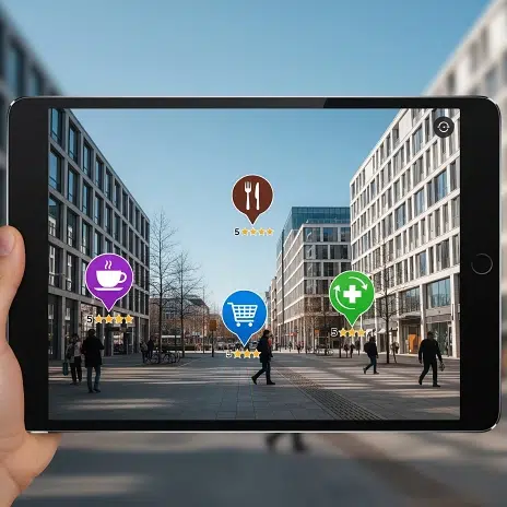
Augmented Reality (AR) is at its most compelling when it seamlessly integrates digital content into our physical surroundings, making it feel truly part of the environment. This profound sense of immersion and utility is largely driven by two intertwined concepts: location-based and spatial AR. These technologies move AR beyond simple overlays, enabling experiences that understand where you are, what's around you, and even the precise geometry of your environment. This context-awareness unlocks a wealth of possibilities, transforming everything from navigation to gaming, and even industrial operations.
Location-based AR, often referred to as geo-based or position-based AR, relies on geolocation data to overlay digital content onto the physical world. It essentially uses your real-world coordinates to trigger and position AR experiences.
While location-based AR is great for knowing where you are, Spatial AR, rooted in spatial computing, takes it a significant step further by understanding the geometry and semantics of your immediate physical environment. This is achieved through a process called spatial mapping.
Spatial mapping is the real-time process of creating a detailed 3D digital representation (a map or model) of the physical environment around the AR device. It essentially allows the AR system to "see" and "understand" the shapes, surfaces, and objects in your room or outdoor space.
Sensors: Spatial mapping heavily relies on advanced sensors, often including:
Depth Cameras: Like LiDAR (Light Detection and Ranging) or Time-of-Flight (ToF) sensors, which measure distances to surfaces by emitting light and calculating the time it takes to return.
RGB Cameras: Standard cameras capture color and texture information.
IMUs (Inertial Measurement Units): Accelerometers and gyroscopes provide motion and orientation data.
SLAM (Simultaneous Localization and Mapping): This core computer vision technique enables the AR device to build a 3D map of its surroundings while simultaneously tracking its own position and orientation within that newly created map. It identifies and tracks persistent visual features in the environment to achieve this.
Mesh Generation: The collected sensor data is processed to create a real-time 3D mesh (a network of interconnected triangles) that represents the surfaces and structures of the physical environment.
Scene Understanding: Beyond just geometry, sophisticated spatial AR systems can also perform semantic segmentation, identifying different types of surfaces (e.g., floor, wall, table) and even objects, allowing for more intelligent interactions.
While distinct, location-based and spatial AR are increasingly converging. For large-scale outdoor AR, GPS provides the initial broad positioning, and then spatial mapping techniques take over for precise, localized interactions. Imagine a city-wide AR game where GPS guides you to a specific area, and then spatial mapping allows a virtual monster to burst out from behind a real statue and realistically move around its base. This combination promises the most robust and immersive AR experiences yet.
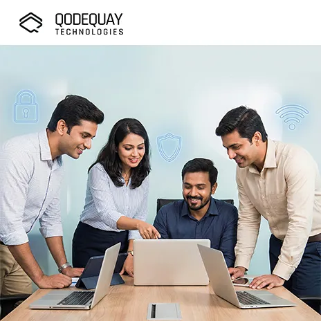
Qodequay is a technology services company that specializes in combining design thinking with advanced engineering to address complex business problems. Our expertise spans a range of modern digital solutions, including AI-Driven Platforms, Web and Mobile App Development, UI/UX Design, AR/VR and Spatial Computing, Cloud Services and IoT Integration, and E-commerce and Custom Integrations. We focus on empathy and intuitive design to ensure optimal user experiences and higher adoption rates.
How can Qodequay’s design thinking-led approach and expertise in emerging technologies help your organization overcome digital transformation challenges and achieve scalable, user-centric solutions? Qodequay's design thinking approach places a strong emphasis on leveraging the full potential of location-based and spatial AR to create transformative user experiences. We don't just understand the underlying technology of geolocation and spatial mapping, we apply this knowledge to craft practical, scalable solutions tailored to your unique business challenges. Our deep expertise in AR/VR and spatial computing allows us to develop applications that provide precise context-awareness and seamless integration of digital content with the physical world, driving higher adoption rates and tangible business value for your organization.
Harnessing the cutting-edge capabilities of location-based and spatial AR requires specialized expertise. By partnering with Qodequay.com, you gain a collaborative team dedicated to finding the right solutions to your business problems. We specialize in designing and developing bespoke AR applications that leverage these powerful context-aware technologies, ensuring your AR solution is not only innovative but also delivers unparalleled precision and immersion, bringing your vision to life in the real world.
Ready to explore how location-based and spatial AR can revolutionize your operations or engage your customers? Visit https://www.qodequay.com/ to learn more about our AR/VR and Spatial Computing services. Fill out our enquiry form today, and let's discuss how we can build your next groundbreaking AR solution!
At Qodequay, we believe that meaningful innovation starts with understanding people. As a design-first company, we lead with deep empathy—immersing ourselves in the everyday realities, behaviors, and desires of your customers.
Only after decoding real-world pain points do we bring in technology as the enabler. This ensures every solution we build is not just technically sound, but intuitively aligned with human needs.
Whether it's:
We design with purpose, and build with precision.
As the CEO and Founder of Qodequay Technologies, I bring over 20 years of expertise in design thinking, consulting, and digital transformation. Our mission is to merge cutting-edge technologies like AI, Metaverse, AR/VR/MR, and Blockchain with human-centered design, serving global enterprises across the USA, Europe, India, and Australia. I specialize in creating impactful digital solutions, mentoring emerging designers, and leveraging data science to empower underserved communities in rural India. With a credential in Human-Centered Design and extensive experience in guiding product innovation, I’m dedicated to revolutionizing the digital landscape with visionary solutions.
Follow the expert :
![]()
February 13, 2026
February 13, 2026
February 13, 2026
February 13, 2026
February 13, 2026